The Mars Pathfinder Landing Site
What are you seeing?
When you look at those neat panoramic views from the Mars Pathfinder, what are you seeing? What are
those various hills and lumps you can see, and how far away are they from the lander? How do the objects in panoramic
views fit in with the satellite images of the area taken by the Viking spacecraft?
I put this page together to show some of these things. There are surface maps of the area around the landing site, with certain features
identified, and the panoramic view from the lander, with the same features identified. It makes for
some fascinating viewing.
Even more striking are stereoscopic views of the landing area, compiled from Viking data. You can see the topography of the area from above
in vivid 3-D, and then match these features with those seen in the panoramic view.
All graphics here are from the various NASA sites. I have added labels to the panoramic views and selected and
arranged the stereographic views so that they may be seen to best effect.
Please let me know if you
discover any errors and--enjoy!
Brent Hugh (bhugh @ brenthugh.com)
Overhead View/Panoramic View
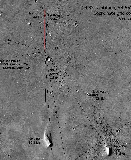
(click on the map for a much larger and more detailed view)
Notice that in the Panoramic View, below, you can see almost all features labeled on the Overhead View above. You will have to download
the more detailed Panoramic View to see them all, because some of them are rather small and faint, right on the horizon.
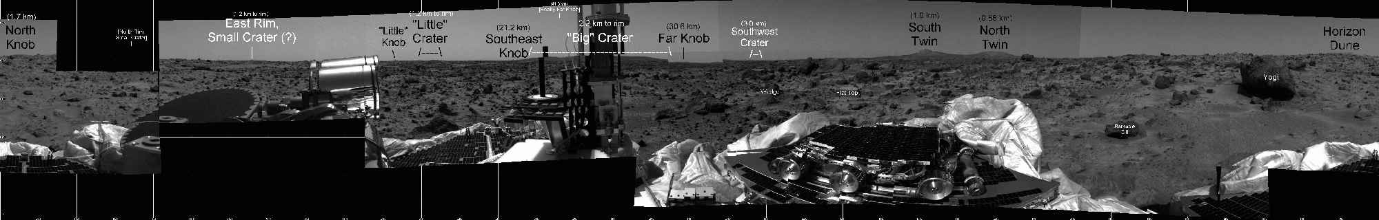
(click on the panorama for a more detailed view)
Below is a closer view of the landing site from above, which shows several features visible in the panoramic view. In particular,
notice "Little" Crater and Rimshot Crater (which is exactly behind the big pole on the lander in this panorama, but
is clearly visible in some of the other panoramas available at the NASA site).

Stereo Views
These stereo views, from Viking orbiter data, are remarkable. They are designed to be viewed with special stereoscopic viewers, but I have set
these images up so that many people can view them directly on the computer screen (or by printing them out, although you'll lose a lot of detail that
way unless you have a really spiffy printer).
The views are narrow enough that you can just diverge your eyes until the two images line up with each other--and, magically, a three-dimensional
view will appear. The technique is similar to that used in viewing random-dot stereograms, and
these directions for viewing stereograms
may help you view the Mars images on this page, as well.
Briefly, the technique for viewing the stereo pairs works like this:
________X____________X________
Above you see two X's. If you diverge your eyes (say, by putting your nose close to the computer screen), you will see four X's--two for
each eye. If you can get your eyes to diverge just right and line up just right (perhaps by moving closer or further from the computer screen
and/or tipping your head slightly side to side), two of the X's will merge and you see three X's.
The Three-X effect is what we're after to view these images. Pick a prominent spot on one of the stereo pairs below (notice that the same spot
appears in each of the two stereo images) and do the same thing to this pair of spots that you did to the X's. When you make
two spots become three, presto! you'll be seeing Mars in 3-D.
Hints
If the images are too wide for you to allow them to line up, you may have to download them and manipulate them to get them to be the right size. I
found that pasting them into my word processor allowed me to align and size them rather easily. These images work fine for me
and my particular computer screen, but you and your computer screen might be different.
Most WWW browsers mess up the colors in the images, so they will look nicer if you download them and view them with a dedicated
graphics viewer.
If you can't view them images by diverging your eyes (various things can make it difficult or impossible),
you can still get a nice effect by putting the two stereo images on top of each other and just flashing from one to the other.
You can print them out and do this manually or just do it on the computer screen (opening the two images and then using
alt-tab to switch between them works nicely in Windows).
North in all the stereo images is the direction indicated by this arrow (note that the stereo images have a different orientation than
the overhead view at the top of this page--in that view, north is straight up):

The exact location of Pathfinder's landing site in these images can be found by comparison with the large image at the top of this page.
Simply click on any stereo image to download it.


A view of the landing site. Big Crater, near the landing site, is approximately 1.5 km in diameter, which
gives an idea of the scale. Just above Big Crater in this image are Twin Peaks. The peaks are about
0.3 km apart. The prominent knob on the upper right side of the image is North Knob; just below it is what I call
Small Crater. All these landmarks (with the possible exception of Small Crater) are visible
from the lander.
This image is maximum resolution from the Viking images (30 meters per pixel).
|


A more expansive view of the area surrounding the landing site. In the upper right corner is Big Crater; above it (just visible) are Twin
Peaks and North Knob. In the lower left corner is Far Knob and on the lower right side, Southeast Knob.
|

This very long view takes you from the landing site near the top (notice Big Crater, Twin
Peaks, and North Knob) all the the way to Southeast Knob, near the bottom. Notice how pointy Southeast Knob
is on top--exactly the way it appears on the Pathfinder panoramas.
|


This is a closeup of Far Knob. You can clearly see terraces, canyons, and the effect of the massive flood
which flowed around Far Knob. The ridge along the top of Far Knob is approximately 5-6 km long.
|


This crater is about 70 km NNE of the landing site--certainly not close enough to see from the landing site. The crater measures 9.5 km
from rim to rim and is very deep. I have included it here simply because the stereo views are so stunning.
|


This is a higher resolution version of the gargantuous crater 70 km NNE of the landing site.
|


Another high resolution view of the gargantuous crater.
|


A longer view of Far Knob. Here you can more clearly see to the "tail" extending from Far Knob, left by the massive flood.
|


A magnified view of the landing site. This doesn't really have a greater resolution than the images above, but just because it' s larger,
it seems like you can see a few more details.
|
The Man from Mars

The Man from Mars
He saw some stars,
Right after he fell
Upon on his ****.
He then forsware
To go in bars--
And that's the tale
Of the Man from Mars.
(And the above is the mugshot he received as a souvenir of the event.)
Actually, it's my passport photos--the next closest thing to mugshots--which
they took with a stereographic camera in order to get the two "identical" photos required by passport regulations--but
that's not a very good story, is it?
Just FYI, **** = a four-letter word rhyming with Mars and explicitly describing the particular anatomical area upon which The Man from Mars landed, and which
has been cleverly disguised to protect unsuspecting internet users, in accordance with the provisions of the
Communications Decency Act.
|
Related sites
See the Mars Pathfinder landing site in stereo (using Viking images).
Courtesy of Tim Parker, Jet Propulsion Laboratory. (This is the source of all stereo views on this page.)
Stereoscopic landscapes of Mars, arranged for free viewing like this site. This is a
stunning site and will give you yet another perspective of Mars!
Maps of
Mars Pathfinder Landing Site, from Viking images, and an explanation of why this particular site was chosen.
Take a Tour
of Ares Vallis, the Pathfinder landing site (courtesy of David Palermo).
Landing
Site Description From The National Space Science Data Center
Ames Research Center Viking
Image Archive Page Of The Mars Pathfinder Landing Site
Other sites maintained by Brent Hugh
Music Instruction Software
The Interactive Internet Piano
Recital--over 70 minutes of classical piano music, in RealAudio format
EarTestonline--online, interactive ear training
The Indecency Page
Brent Hugh's home page
This page was put together by Brent Hugh
(bhugh @ brenthugh.com).
Feel free to email me with any problems, suggestions, or just random thughts.
This page was made in about 1999.

